In a hurry? My top tips
- Use Plotaroute for route planning
- Use Organic Maps for offline navigation - download maps in advance after which you don't need a cellphone signal or Wi-Fi. Import your own KML files created with (e.g.) Plotaroute into Organic Maps using the steps you'll find below.
- In Organic Maps' settings screen, enable Allow Screen to Sleep. This will conserve battery very effectively.
- On Android use the Smart Lock feature to stop your phone from locking as long as it is in use (connected to a trusted device or one of the other options). This means you can wake up Organic Maps with a quick tap to your phone's screen and the map will be displayed immediately. No need to enter a PIN or anything.
Navigation
Having planned your route, the next question is how you're going to follow it. For shorter rides or those that only span a day or two, this is easy. You have a smartphone. It has a map and navigation application such as Google Maps. If you've planned your route using a suitable tool, you should be able to export it in a format like KML and then import it into your navigation tool of choice and that's it, you're away.
But this can be more involved if you're undertaking a multi-day trip, perhaps including many hours in the saddle each day. There are a number of issues:
- How to carry your phone
- Smartphone battery life
- Mobile network and internet availability
How to carry your phone
There are plenty of options for how you carry your phone so that it is easy to access for navigation purposes. There are handlebar mounted, waterproof holders which look good. I have a frame bag which has a compartment with a transparent cover that is made for exactly this purpose, so that's what I use. That said, it's not exactly waterproof (as I discovered to my horror!) so in heavy rain I have to put a rain cover over it. However, in pouring rain I think I'd still have problems reading the screen through the frame bag cover whether it was 100% waterproof or not.
Most phones have touch screens so if you buy a holder of any sort for your phone, make sure the touch screen can still be used, otherwise you will need to take your phone out every time you need it, and that will get annoying very quickly.
Of course if it's a nice sunny day, you could just put your phone in one of your jersey pockets. Just don't lose it :-)
Smartphone battery life
Your smartphone's navigation application will be using GPS and GPS is a notoriously greedy consumer of battery power. And the other major battery power user of your phone is the screen. The more time it spends on, the more battery power will be used. But of course you need the screen on at least some of the time and you absolutely need GPS for the navigation system to work! So, what's the best approach to squaring this particular circle?
Smartphones have options that allow you to use less battery life. I have an Android phone so can cover some useful Android tips here. iOS users, I'm afraid you will just have to do some exploring on your own.
Android has a setting called Battery Saver. Don't be surprised when I tell you that it's a mode which...saves your battery. It does this by switching off non-essential background processing, so for example your emails will not download until you are running the email application in foreground. I also set my screen's display timeout to the 60 seconds, meaning that if I don't interact with it in a 60 second period, the screen switches off. I could go as low as 15 seconds, but I do still need to be able to use the phone and 1 minute seems to work well for me.
But there's a problem here. Like most people, I have security enabled on my phone so that when the display goes to sleep, it also locks so that I have to enter a PIN or use fingerprint recognition to unlock it. There's no way I want to be doing this while I'm riding and I also have no desire to stop every time I want to check the route. Luckily, I also use a Suunto GPS smart watch. The main reason for this is to record my ride and associated stats. It's an efficient device and the battery lasts much longer than that of a smartphone. It also uses Bluetooth to share data with the smartphone when I sync at the end of a ride and this offered a solution. Android has an option called Smart Lock which lets you specify special circumstances in which the screen should not lock when the display goes to sleep. One of the possibilities is to prevent the screen from locking when the phone is connected over Bluetooth to a trusted device. Like my watch! So, problem solved. When cycling, my phone sits in the frame bag in battery saver mode and most of the time, the display is switched off. But the phone is not locked. If I want a quick look at where I am on the map to make sure I'm still on route, I just tap the screen a couple of times with my finger and it activates and shows me the navigation application and my current position.
This combination of measures has been proven to work very well for me. The first time I tried this, I cycled 70 miles on a route I had never taken before, so I had to use my phone in a representative way. By the time I finished the ride, after 5 hours in the saddle and the navigation app running the whole time, my phone's battery level was showing 86%, which is remarkable. The phone is a OnePlus 5 by the way, so not exactly a top end phone.
Based on this initial experiment, allowing for taking some photos and having a few WhatsApp conversations, I estimate the battery should get me through a couple of days no problem.
Mobile network and internet availability
Some mobile navigation applications only really work when there's an online connection to the internet available by Wi-Fi or a mobile network. Clearly when you're out on the road, it's the mobile network that you need. But which mobile network? Which country are you cycling in? Will you be crossing borders?
If you access a mobile network that you are not a subscriber to (your home network), your phone will be said to be roaming. Most phones allow you to enable or disable the use of data when roaming and the reason for this is that roaming charges can be very expensive.
I'm based in the UK and thanks to our prior membership of the EU, there are no roaming charges to be paid when using a network in another EU country. But this will almost certainly not last. The UK is currently not a member of the EU but still subject to its laws. Once we have completed the withdrawal process (over the next few months) there will be nothing to stop networks reintroducing roaming charges to UK network subscribers, so things could get very expensive once again for travellers.
In anticipation of roaming charges coming back or with travel through non-European countries in mind, there are a few things that can be done to reduce costs.
1. Download maps for offline use when connected to free Wi-Fi
Some applications support the use of offline map data stored on your phone rather than accessed as needed over the network. Google Maps supports this, for example. You do need to remember to download the map for areas you will be travelling through though.
2. Buy a local SIM card
If you can't beat 'em, join 'em! It might be a little inconvenient but if you're cycling into another country, one option is to make your first stop at any town large enough to have a phone shop you can buy a SIM card from and get yourself onto one of the local networks. You'll need to have a large enough data allowance for your needs but don't forget that making calls could save your proverbial bacon in an emergency too.
Applications and Other Tools
Here's what I use for in-ride navigation.
As described in my post on
route planning, I use a tool called
plotaroute for route planning. Having prepared my route, I export it as a KML file, which is a format many tools support and so useful for passing route data between tools.
Favourite offline navigation App: Organic Maps
Google Maps works offline as long as you have remembered to download the map data for offline use in advance. Some functions, such as route finding ("Directions") will not work if you have no internet access though and I've even had problems using routes loaded into Google MyMaps when I didn't have a signal.
An alternative is to use the free mobile application,
Organic Maps. This app is designed specifically for offline use and downloads openstreetmaps data either in advance or on demand as it becomes required (assuming you have network access!). I've been using it for a while now and I think it's pretty much perfect for bikepacking.
To import a KML route file into Organic Maps on Android, either go into the Bookmarks screen and use the Import function or find your KML file with a file manager application and open the file. You should get offered Organic Maps as one possible application to use.
1. Change the LineStyle
If your eyesight isn't that great, it can be helpful to improve contrast by changing the colour of the line which indicates the route to something more suitable. I like to set the line colour to black, for example. Unfortunately you cannot do this through the app itself. Instead, edit the kml file as follows, before importing it.
Edit KML file. Find the LineStyle element. Change colour to FF000000 where FF is the transparency (opaque) and the remainder is the RGB colour code. Set width to 6.
<LineStyle>
<color>FF000000</color>
<width>6</width>
</LineStyle>
Information on colour codes can be found at a great many web sites such as this one:
https://htmlcolorcodes.com/
2. Let the Screen Sleep
When I use Organic Maps, especially when the trip spans more than one day, I am extremely keen to safeguard the battery on my phone as I might not be able to charge every day. Even the battery pack I carry for that very purpose is treated as a precious resource. So I do not want my smartphone screen to be on all of the time. The screen on a modern, high-resolution smartphone is one of the greediest consumers of battery power that there is.
By default, when you have the map displayed in Organic Maps, the screen will not sleep....ever. It will stay on. This is convenient for some situations but not for mine. Luckily, the app is open source which means the code is published for all to see and if you have programming skills, you can make changes and offer them to the primary team that manage Organic Maps for inclusion in the main released app. I have a background in software development and so was able to make a change which the team were kind enough to incorporate in the released app.
Go into Settings and scroll down and you'll find the Allow Screen To Sleep option. Enable it. Now you can check your route every now and again whilst cycling and the screen will go to sleep at whatever time interval you have set in the Android settings screen. I have my GPS watch paired with my phone and use Android Smart Lock so that the phone never locks as long as it is connected to this trusted device (my watch). Therefore after checking my location and whether I'm on route or not, I let the screen sleep so it saves battery. It doesn't lock the screen though so when I need to check again I just tap the screen and swipe up. This wakes the screen and I see the map again. It takes a moment to update my location as GPS tracking is suspended while the screen is asleep, but that's fine. I don't mind waiting a few seconds while I'm continuing to pedal and I very much do mind wasting my battery. Perfect!
At this time (June 2021), this feature is only available on Android.
See https://github.com/organicmaps/organicmaps if you're interested in the code.
Other apps worth looking at:
Google My Maps
I then import the KML route into
Google My Maps by creating a new map and then selecting Import and selecting my KML file.
 |
Importing a KML file into Google My Maps
|
 |
Google My Maps
|
I then name and save the route in Google My Maps.
My Maps allows route planning but it's nothing like as easy to use as plotaroute. The only reason I use it is because a route that is saved by My Maps becomes available within Google Maps.
Google Maps
To load a My Maps route into Google Maps, select Saved from the bottom of the screen, then Maps. Select your route from the list and it will be overlaid on the map. If you don't see your route, access it from My Maps and it should then become available in Google Maps (which I think only lists so many of your most recently accessed routes).
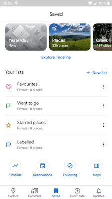 |
Saved items in Google Maps
|
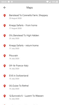 |
Maps created or imported to Google My Maps
|
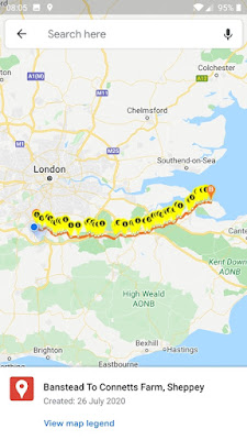 |
Selected route overlaid on Google Maps
|
Once the selected route is open in Google Maps, your current position will be shown and you can simply keep an eye on whether you've strayed off route or not. Obviously, you can zoom to whatever level works for you.